

By DONALD WITTKOWSKI
Uh-oh, here we go again.
More stormy weather bringing drenching rains, gusty winds and street flooding will hit Sea Isle City and the rest of the shore this weekend, continuing the unusually wet conditions that marked most of winter and now the first precious days of spring.
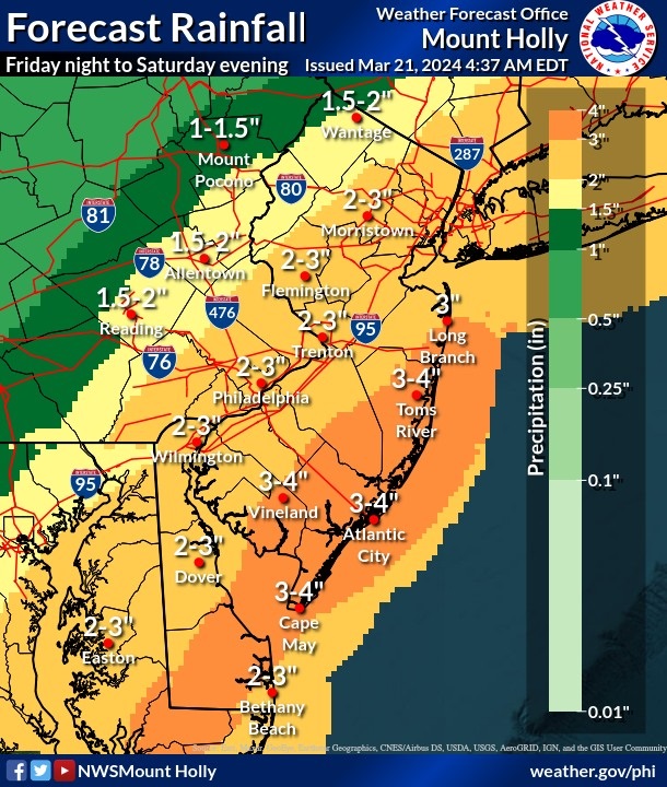
Up to 3-4 inches of rain will fall at the shore starting Friday night and continuing through Saturday night, according to the National Weather Service forecast. Soaking rain will add to the soggy weather that we experienced in December, January and part of March.
The wet weather in early March has already brought the equivalent of a full month’s worth of rain to some areas of the state – and it’s only going to get worse this weekend.
“Saturday morning, the rain starts in earnest,” said Mike Jargowsky, Sea Isle’s emergency management coordinator.
Jargowsky has been watching the storm forecasts in the past few days. He noted that the severity of the rain, winds and flooding will depend on the storm track. He said there could be big differences if the storm tracks 50 miles closer or farther away from the coast.
Depending on the track, the storm could blow through the area relatively quickly, or stall off the coast and simply linger, he pointed out.
“A jog to the right or left changes everything with a low-pressure system,” he said.
For now, Jargowsky is expecting heavy rain through Saturday night, minor, if not moderate, flooding in Sea Isle and steady winds in the 20-mph range, with gusts even higher. The forecast calls for strong southeast winds gusting up to 45 mph.
“Most of the time here, it’s the water that’s the main thing,” Jargowsky said of street flooding being the chief concern in Sea Isle. “But sometimes it’s the wind.”
As is Sea Isle’s standard practice with strong coastal storms, Jargowsky plans to issue a weather alert to the public ahead of this weekend using the city’s reverse 911 system and email and text blasts.
“It’s always good to be on the safe side,” he said of the importance of the storm warnings.
Jargowsky works with Police Chief Anthony Garreffi, Public Information Officer Katherine Custer and Sea Isle’s Public Works department to get the weather alerts out to the public. He also incorporates storm information from the Cape May County Office of Emergency Management.
Sea Isle’s storm warnings typically include information about the amount of rain, flooding and high winds predicted by the National Weather Service. Of particular importance at the shore is the flood forecast.
“I always caution against driving through floodwater,” Jargowsky said.
Residents should move their cars and trucks to higher ground before the storm. In Sea Isle, one of the best places to park during storms is at the library lot at 48th Street and Central Avenue, Jargowsky said.
In advance of the heavy rain, crews from the Public Works department have already checked the storm drains and grates to make sure they are clear of any debris, he said.
The police department will have its high-water vehicles on standby in case they are needed for rescues, Jargowsky added.
Altogether, the National Weather Service has issued a flood watch for 19 New Jersey counties, including Cape May, for the weekend. No coastal flood advisories or warnings have been issued yet, but residents are asked to closely monitor the forecast and weather conditions. Flood advisories and warnings are more serious than flood watches.
Gusty winds of up to 45 mph may be strong enough to topple trees or snap branches. Falling tree limbs could trigger power outages during the storm Saturday, according to the forecast.


