

By MADDY VITALE
State and federal authorities, along with a nonprofit organization, partnered to develop a flooding study in 13 communities and the result was a “roadmap” of key areas that need to be addressed, along with a focus on what is working.
The report was unveiled by the New Jersey Coastal Coalition. It detailed a study conducted by the U.S. Army Corps of Engineers and the state Department of Environmental Protection during a news conference in Avalon on Tuesday.
Flood risks were identified and studied in Ocean City, Upper Township, Sea Isle City, Egg Harbor Township, Avalon, Stone Harbor, North Wildwood, West Wildwood, Wildwood Crest, Cape May City, Cape May Point, Downe Township and Woodbridge Township.
The findings of the 110-page report provide specific locations where flood risks exist in the communities studied, and how the communities may apply for grant funding to improve resiliency efforts.
“This report is a critical resource for our communities who want to target flood vulnerabilities to protect lives and property,” New Jersey Coastal Coalition Executive Director Tom Quirk said.
In 2019, the Coastal Coalition contacted the Army Corps with a list of 13 communities that should be studied.
The results of the report, Quirk noted, are “compelling, informative, and useful to address these hazards to better protect our towns.”
The communities, such as Ocean City and Sea Isle City, experience periodic flooding from high-frequency storm events and tidal fluctuations, according to the report.
In addition to detailing facts about flooding in the areas, the report identifies means and methods to better protect the communities with conceptualized preliminary solutions.
“To me, the most important thing that happened today — on a bright, sunny day at the end of June — is that the municipalities at the Jersey Shore are working on the flooding issues,” Quirk said of the news conference. “When the storm comes up the coast, it is way too late. We have to be prepared.”
Quirk, a Ventnor resident in Atlantic County, said some residents at the Jersey Shore need to change a common mindset.
“We have to get away from the fix-and-forget mentality,” he pointed out. “We have to realize we are on the Jersey Shore. Come with your family and enjoy, but five days a year, we will flood. When they tell you to evacuate, evacuate.”
Cape May County Emergency Management Director Martin Pagliughi, who is also the mayor of Avalon, was the keynote speaker at the news conference.
He called the report “beneficial to communities who wish to apply for grant opportunities that will assist in the remediation of these flood risks.”
“There is a new round of funding to support resiliency projects and this report will help serve as the key to unlock these funding opportunities for communities who are serious about flood resiliency,” Pagliughi said.
As for flood ratings, Avalon is currently the only community in the state with a Class 3 rating in FEMA’s National Flood Insurance Program’s Community Rating System, or CRS. The rating allows for discounts on homeowners’ flood insurance. In Avalon’s case, it gets a 35 percent discount.
Ocean City has a Class 4 CRS rating with a 30 percent discount and hopes to become a Class 3 rating in the future.
Some of the flood-prone areas the Army Corps studied in Ocean City were Haven Avenue, Simpson and Haven Avenue from 56th Street to 52nd Street and West Avenue from 59th to 56th Street.
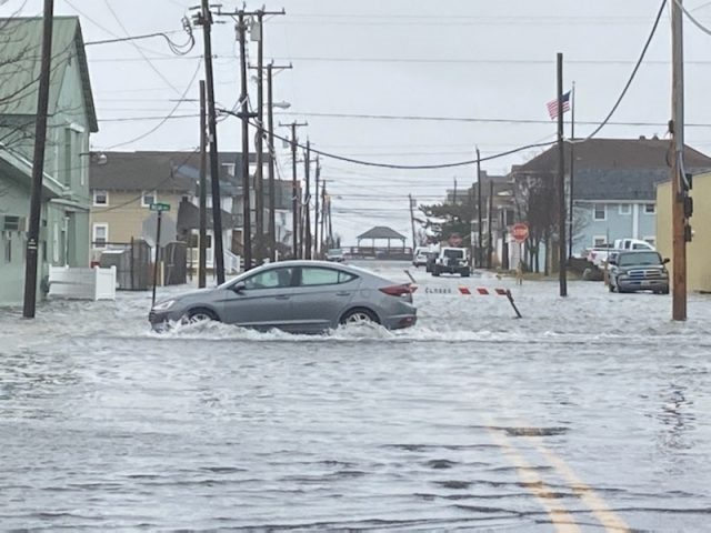
Sea Isle City is currently a Class 4 rating. The city is in the process of regaining the Class 3 rating it once had by approving a new comprehensive flood-prevention ordinance.
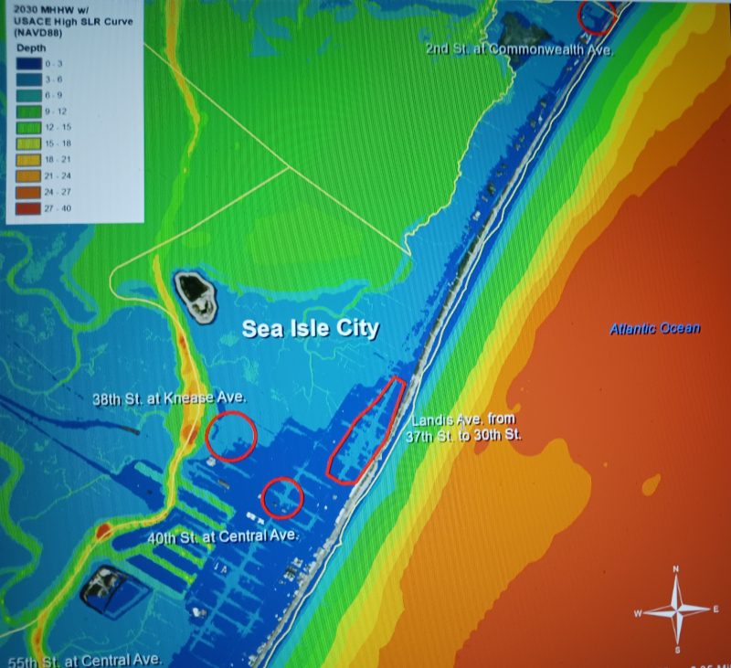
Some of the areas studied in Sea Isle were Landis Avenue from 37th Street to 30th Street. Other areas viewed were 40th Street at Central Avenue and 55th Street at Central Avenue and 38th Street at Kneass Street.
In addition to identifying areas of flooding in the communities studied, the report provides information, including graphical depictions, of anticipated sea level rise and the impact on coastal communities in the years 2030 and 2080, the news release said.
Evacuation routes, environmentally sensitive areas, essential services, and methods of storm communication are all outlined in the report.
Quirk said he and the Coastal Coalition will continue to work with state and federal agencies and communities that deal with flooding issues.
The New Jersey Coastal Coalition is a nonprofit group comprised of 38 floodplain communities that meet monthly in a workshop setting to discuss flooding issues. The coalition was formed in response to Super Storm Sandy in 2012.
“Key to our concept is having a regional idea. We are all in the boat together. We don’t care about politics,” Quirk said. “We work on flooding. We don’t take positions on climate change or windmills. We are about flooding, and what we can do to prevent it.”
Quirk added that the report is beneficial to those who are interested in taking steps against flooding.
“This is a roadmap to vulnerabilities of flooding,” he said of the study that took several years. “Some we already knew, and others we didn’t. It is a very detailed report with information about each of the 13 municipalities.”
He noted that the Army Corps and the DEP provided the funding for the report. To view the report, click here: https://drive.google.com/file/d/12EzYiHP92r8DjTJNyZxV7thtFrajuyqa/view.


