
Floodwater swamps West Spruce Avenue in front of Rick's Seafood in North Wildwood. (Courtesy of Rick's Seafood)
Streets were transformed into rivers. Beaches were badly eroded. Boardwalks became ghost towns.
Shore communities endured a second straight day of flooding, beach erosion and rain from a nasty nor’easter that was particularly dangerous during the high-tide cycles.
With roads swamped with stormwater, towns pleaded with motorists not to venture out in the storm unless it was absolutely necessary.
“We ask that those in the flood prone areas of the City please take precaution early by moving your vehicles to higher ground and secure outdoor items. Also, all motorists are NOT permitted to drive your vehicle through flooded streets,” North Wildwood said in a message on its Facebook page.
Ocean City joined with North Wildwood and other shore towns in warning motorists that the wake caused by driving through flooded streets can severely damage homes and property.
“We really need people to stop driving down flooded streets. They are doing more damage than the storm,” Ocean City Mayor Jay Gillian said.
Raging waves pounded the seawall on the Avalon side of the Townsends Inlet Bridge connecting Avalon and Sea Isle City. The bridge was closed to traffic temporarily because of flooding on the Avalon side, the Sea Isle Police Department said in a weather alert.
Towns were bracing for more flooding caused by the afternoon high tide on Monday. The National Weather Service issued a Coastal Flood Warning through 8 p.m. Monday.
“Confidence remains high that we will see an additional round of significant impacts from moderate to major coastal flooding during the high tide cycles this afternoon along the Atlantic coast,” the Cape May County Office of Emergency Management said in a statement.
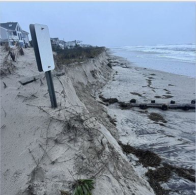 Significant dune damage occurs in Strathmere at the beach pathway on Sumner Avenue.
Gillian said he had his “fingers crossed” that flooding caused by Monday’s high tide wouldn’t be as severe as the one Sunday.
“Let’s hope Mother Nature is kind,” he said prior to high tide.
After high tide was over, Gillian reported that Ocean City was “very fortunate” that Monday’s peak flood levels were well short of what was predicted.
“The worst flooding is behind us, and we anticipate getting back to normal as of tomorrow. Our pumping stations are fully operational, and once the tide drops, they will be able to move water off the streets effectively,” he said in a storm update to the public at around 3:30 p.m.
Gillian noted, though, that there were still deep floodwaters on the streets after high tide and urged motorists to stay off the roads until they were clear.
“Not only are you putting yourself and your vehicle at risk, but the wakes generated by cars plowing through floodwaters can damage people’s homes and property,” he said.
There will likely be one more Coastal Flood Advisory issued in Ocean City for Tuesday’s high tide at 3:13 p.m., but the flooding will be minor compared to Sunday and Monday’s flood levels.
The storm is expected to mostly be over by Tuesday.
“I want to thank everybody who took precautions to prepare for this storm and who checked on neighbors. That’s what Ocean City is all about,” Gillian said.
Facebook video showed that Sunday afternoon’s high tide caused moderate to major flooding that was widespread at the shore. In some cases, the floodwater was nearly as high as the fire hydrants lining the streets.
North Wildwood said flood levels were expected to be slightly higher than the flooding caused by Hurricane Erin when it generated rough surf while churning up the East Coast in August.
Flooding was expected to hit parts off West Spruce, Maryland, Delaware, New York, New Jersey and Central avenues, along with side streets in North Wildwood.
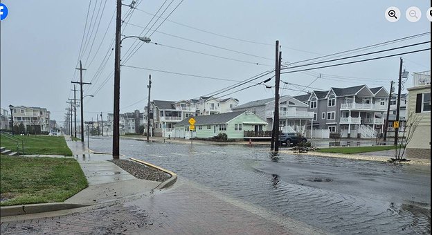 Central Avenue at 48th Street is flooded in front of the Sea Isle City Library.
Severe beach erosion and dune breaching were other concerns. The high surf left some beaches barren or with only a little bit of the top layer of powdery sand. Dune erosion was serious in Strathmere and other towns, photos and video posted on Facebook showed.
“Severe beach erosion and dune breaching are possible due to very high surf conditions,” the Cape May Police Department said in a weather statement.
Dunes serve as the first line of defense during coastal storms, providing great barriers of sand to protect homes, businesses and other property.
On Sunday, gusty winds combined with the heavy rain and flooding to make conditions even more dangerous. Top wind gusts were clocked at 59 mph in Sea Isle City, 52 mph in Avalon and 51 mph in Ocean City and Cape May Harbor. By Monday morning, the winds diminished dramatically and a High Wind Warning was lifted.
Drenching rains kept people off the boardwalks and promenades from Atlantic City to Cape May. Footage on the Weather Channel showed long stretches of the Atlantic City Boardwalk empty.
The storm’s impacts were also felt in other parts of the state. Acting Gov. Tahesha Way declared a State of Emergency across all 21 counties in New Jersey to prepare for the storm.


