Farming, an industry once dominated by manual labor and unpredictable weather conditions, has evolved into a highly sophisticated, data-driven business. At the forefront of this transformation is Global Positioning System (GPS) technology, powered by advanced tools like GNSS antennas, which have revolutionized how farmers manage their operations. This technology enables precision farming - an approach that leverages location data to optimize agricultural practices, increase crop yields, reduce environmental impact, and enhance the overall efficiency of farming operations.
From planting crops to harvesting, GPS technology has become an integral part of modern agriculture, offering farmers the ability to make more informed decisions that impact both productivity and sustainability.
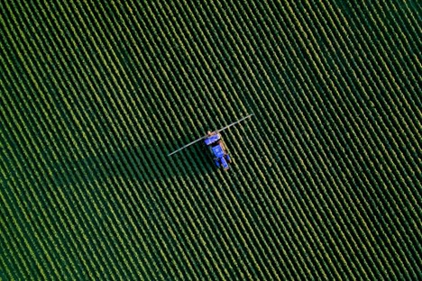
Global Positioning Systems, which originally began as a military tool, are now a common feature in everyday life, from smartphones to vehicles. In agriculture, these systems use satellites to determine the exact location of farming equipment in real-time. This data is then used to guide machinery on the field with high precision. In modern precision farming, GPS is integrated into a range of equipment such as tractors, harvesters, planters, and sprayers, enhancing productivity and enabling farmers to monitor and manage their land with far greater accuracy than ever before.
When combined with Geographic Information Systems (GIS) and variable rate technology (VRT), it creates a system that provides farmers with actionable insights to optimize the use of resources. Whether it’s planting seed, fertilization, irrigation, or pest control, this technology allows farmers to make data-driven decisions, ultimately improving crop yield and reducing waste.
Farmers can use GPS to ensure their equipment follows the most efficient routes across their fields, minimizing overlap and reducing fuel consumption. For example, in planting crops, GPS-guided tractors can ensure that rows are evenly spaced, maximizing available planting area and minimizing seed waste. This level of accuracy can also reduce the need for rework or adjustments, which in turn lowers operational costs and increases farm output.
Machinery can also operate autonomously or semi-autonomously, meaning that farmers can complete tasks such as tilling, planting, and spraying without needing to be physically present. This increases the amount of time farmers can dedicate to other tasks, such as monitoring crop health or managing logistics. Automated systems are also less prone to human error, further enhancing operational efficiency.
Precision farming allows farmers to apply the right amount of resources, whether it’s water, fertilizer, pesticides, or herbicides, at the right time and place. This targeted approach minimizes waste, reduces costs, and limits the environmental impact of farming practices.
For instance, farmers can map out the variability in soil types and nutrient levels across their fields. By understanding these variations, they can apply fertilizers or water only where needed, rather than uniformly across the entire field. This leads to more efficient use of inputs, improved soil health, and optimized crop yields.
Furthermore, GPS systems can be used to monitor moisture levels across different parts of a field, allowing farmers to adjust irrigation systems accordingly. Over-irrigation and under-irrigation are common problems that can negatively affect crop growth.
Modern GPS systems, when integrated with other technologies such as remote sensing and drones, provide real-time data on crop conditions. These systems can track crop health, monitor growth stages, detect signs of disease, and identify areas that need attention. By collecting and analyzing this data, farmers can make timely interventions, such as adjusting irrigation or applying pesticides only where necessary.
In addition, GPS data can be used to create field maps that track plant health over time, allowing farmers to identify patterns and make informed decisions about planting and harvesting. With the help of satellite imagery and sensors, farmers can detect issues such as pest infestations, nutrient deficiencies, or soil compaction before they spread across the field.
The integration of satellite data with crop management software further enables farmers to visualize and analyze trends, giving them a comprehensive view of their farm’s performance. This proactive approach to crop management helps farmers optimize their practices and increase the likelihood of a successful harvest.
One of the most pressing concerns in agriculture today is sustainability. GPS technology can help mitigate the environmental impact of farming by promoting more efficient use of resources. By reducing input waste, such as fertilizer, pesticides, and water, farmers can decrease runoff, protect local ecosystems, and improve soil health.
Location-guided sprayers can precisely target areas that need pest control, reducing the overall use of chemicals and minimizing the impact on surrounding non-crop areas. Similarly, GPS-based fertilizer application systems can apply nutrients where they are most needed, preventing overuse and reducing the risk of nitrogen leaching into groundwater.
This technology helps farmers reduce fuel consumption by optimizing the routes taken by machinery. More efficient field navigation means less time spent on the tractor, which lowers fuel consumption and reduces the carbon footprint of farming operations.
Harvesting is one of the most critical stages of the farming cycle, and GPS technology plays a key role in maximizing yield during this phase. In combination with yield mapping, this data allows farmers to track the yield of crops across different parts of the field. By analyzing this data, farmers can identify areas with high or low productivity, which can inform decisions about future planting strategies.
Yield mapping also provides valuable insights into the effectiveness of inputs, such as fertilizers or irrigation. If certain areas of the field show lower yields despite receiving the same treatment, this may indicate that adjustments need to be made in terms of inputs or soil management.
GPS-enabled combines and harvesters use real-time data to adjust harvesting speeds and optimize the process. This ensures that crops are harvested at the optimal time, minimizing losses and improving overall yield quality.
Autonomous tractors, sprayers, and harvesters are a game-changer for modern agriculture. GPS allows these machines to navigate fields with minimal human intervention, increasing productivity and freeing up labor for other tasks. These machines can work around the clock, performing repetitive tasks like planting or spraying while maintaining the high level of accuracy that is critical for precision farming.
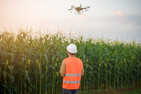
Drones are increasingly used in agriculture for crop monitoring, field surveying, and precision spraying. Equipped with GPS systems, drones can fly over fields, capture high-resolution images, and use sensors to gather data on crop health, moisture levels, and pest activity. This data can then be used to make precise, data-driven decisions about crop management.
GIS technology plays a crucial role in visualizing and analyzing the data collected by GPS systems. Farmers can use GIS software to create detailed maps of their fields, track soil types and nutrient levels, and monitor the overall health of their crops. GIS helps farmers make better decisions regarding crop rotation, fertilization, and irrigation practices by providing them with a comprehensive overview of their fields.
The potential for GPS technology in agriculture is vast, and the future promises even more innovation. As technology becomes more accurate and integrated with other technologies, farmers will be able to make even more precise decisions that further enhance productivity and sustainability. The future may see the widespread use of fully autonomous farms, where GPS-guided machinery works in tandem to plant, tend, and harvest crops without the need for human intervention.
The integration of artificial intelligence and machine learning with GPS data will also allow farmers to make predictive decisions based on weather patterns, crop health, and soil conditions, enhancing the overall efficiency of farming operations.
The continued development and integration of GPS systems will help farmers meet the challenges of the 21st century, ensuring that agriculture remains a vital and sustainable industry for generations to come.


