

By DONALD WITTKOWSKI
Sea Isle City is using drainage improvements, road projects, berms, rock walls, a stormwater pumping station, flashing road signs and even a “flood cam” to fight flooding on the low-lying barrier island.
Everything, it seems, but the proverbial kitchen sink.
But actually there is still much more to come, according to a new report that envisions combining high technology with more traditional flood-control methods such as road construction to reduce the threat of stormwater amid rising global sea levels.
“The City of Sea Isle City will continue its efforts to manage future flooding issues for the island using proven and innovative techniques of flood management practices,” the report concludes.
The 30-page document represents an update of the city’s 2018-2019 floodplain management plan. Every five years the report must be updated as part of Sea Isle’s participation in the National Flood Insurance Program, or NFIP, City Solicitor Paul Baldini explained.
Sea Isle is among only a few cities and towns in the country to have obtained a “Class 3” community rating within the NFIP, entitling local property owners to a 35 percent discount on their flood insurance policies.
Once in danger of being thrown out of the NFIP in 1993, Sea Isle has undergone a dramatic transformation since then and is now considered one of the nation’s leading communities in flood prevention, Mayor Leonard Desiderio has said.

Desiderio says in remarks in the introduction of the floodplain management report that Sea Isle “faces many challenges to remain a viable community for many years into the future,” including rising sea levels, more severe coastal storms and nuisance flooding.
“As mayor I am committed to facing these challenges on behalf of the visitors and residents of the City,” he says in the report. “These challenges will be met by my administration through dedicated hard work, creative ideas, long term thinking and planning and innovative projects to protect our community.”
The new report was compiled by Sea Isle’s floodplain committee, which is headed by Neil Byrne, the city’s construction official and floodplain administrator. Desiderio credits Byrne for helping the city to make “huge strides” in flood protection.
In the report, the city says it will continue to work in partnership with the public on the planning and construction of flood-control projects.
“The City has long recognized the importance of involving the public in floodplain management planning,” it says.
Over the years, Sea Isle has implemented a series of major flood-mitigation initiatives, such as restoring the beaches and dunes, building bulkheads along the bayfront, upgrading the drainage systems and erecting berms and levees.

Baldini described Sea Isle’s flood-mitigation program as “very aggressive.” He said it makes sure the city is always “looking forward” for ways to prepare for future storms and flooding.
“I would view Sea Isle’s flood management policy as very aggressive. If we aren’t proactive, we’re going to get overwhelmed,” Baldini said in an interview Monday.
In 2019, the city added to its flood-control strategy with new technology and some older, proven methods to protect the community from stormwater, including road construction.
Cape May County, for instance, completed a $12.7 million, multiyear reconstruction of Sea Isle Boulevard that elevated the town’s main entryway 4.5 feet above flood levels.
Targeting one of the city’s most flood-prone neighborhoods, Sea Isle built its very first stormwater pumping station in 2019 at the bay end of 38th Street at Sounds Avenue. The nearly $800,000 pumping station will intercept floodwater and channel it back into the bay much faster than it would normally take to drain off the streets after a coastal storm.
The pumping station is complemented by repaved roads, new drainage improvements and a nearly 4-foot-high rock wall that runs along the sides of 38th Street to protect the bayfront neighborhood.

A series of flood stations are being considered for other flood-prone neighborhoods. The next one is proposed for the area between 43rd and 45th streets between Landis Avenue and the bay.
Also in 2019, Sea Isle installed a citywide early warning system to keep residents and tourists away from flooded areas. It is billed as the largest project of its kind for any municipality in New Jersey.
The flood-warning system includes 78 flashing road signs scattered throughout town in neighborhoods most vulnerable to stormwater. Sensors detect rising floodwater and activate the flashing signs to warn motorists of danger.
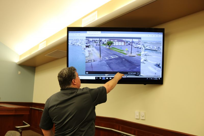
Another high-tech tool installed in 2019 is a “flood cam” that livestreams images on a 24-hour basis at the corner of 40th Street and Central Avenue, another area in town that gets swamped with stormwater. Serving as another early warning system for flooding, the webcam will help residents and visitors to avoid stormwater as they travel around the city.
In the future, Sea Isle plans to broaden its flood-control strategy by elevating more roads, building more pumping stations and adding more berms in vulnerable neighborhoods. Berms consist of a combination of dirt wrapped in a geo-textile material and a stone wall that acts as a barrier against stormwater.
High technology will also continue to be used to warn residents and visitors of flooding. The report notes, for instance, more flood-related information will be added to the city’s mobile app.
Separate from the city’s efforts, the U.S. Army Corps of Engineers is conducting a five-year study of the bays that will consider the possibility of building large gates to contain flooding along the coast, including Townsends Inlet and Corson’s Inlet in the Sea Isle area, Baldini said.
Overall, Baldini estimates it will take millions and millions of dollars to implement different parts of Sea Isle’s floodplain management plan in coming years.
Desiderio, who is also a Cape May County freeholder in addition to serving as Sea Isle’s mayor, has said he will pursue county, state and federal grants to help the city finance its flooding projects.


